QSOs between PA and EA8 on 144 MHz
(2022-07-24) PE1ITR
The number of radio propagation openings on 144 MHz between PA and EA8 can be counted on one hand. The big opening nn July 22, 2022 reminded me that for me the last previous opening was in August 2013. That's 9 years ago!
Then it occurred to me that it would be useful to publish statistical information on my website about when such openings are most common and which propagation mechanism mainly underlies. In this way, the conditions in which such an opening occurs are easier to recognize.
The distance between EA8 and PA is approximately 3200 km. The maximum distance of a single hop E-skip is about 2400 km. Clearly this single hop must be extended by other phenomena. There are several factors that must coincide.
My previous QSOs to EA8
Since getting my hamradio license it took 30 years before I worked on 144 MHz my first EA8. That happened in 2012. The following year it happened again. You don't understand it had to take 30 years.
Then I made two maps of the situation. And although that was not so clear to me at the time, almost all openings between PA and EA8 have more or less the same radio propagation mechanism. More on this later.
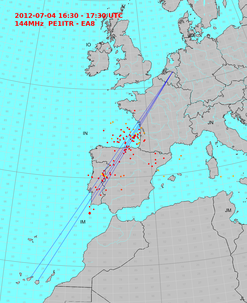
Fig 1: situation op 2012-07-04
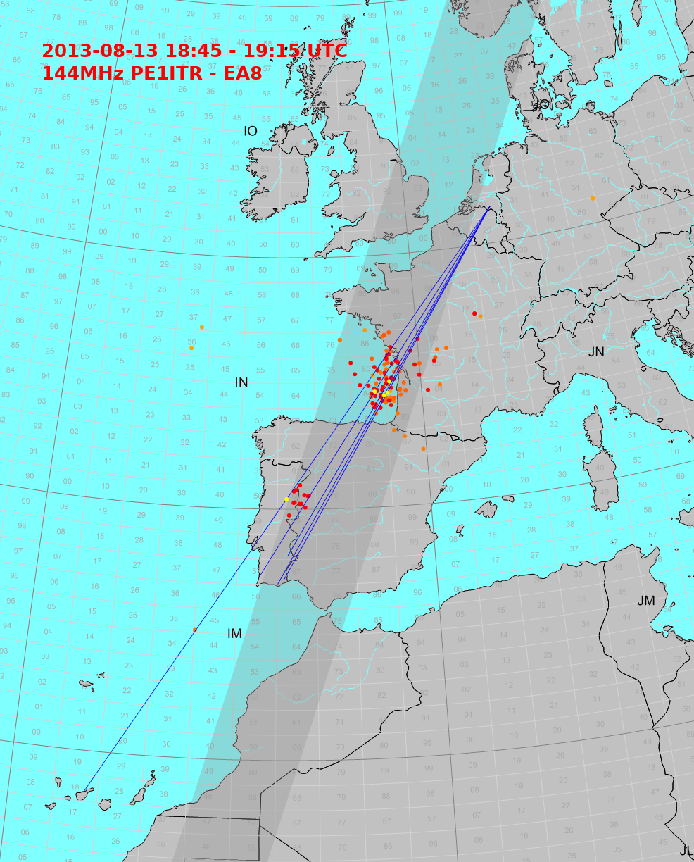
Fig 2: situation on 2013-08-13
These are old cards with also confusing irrelevant information. It can be seen that the reflection point of the first E-skip hop is above the Bay of Biscay. Signals then end up in the sea west of Portugal after which the path continues to EA8. In the past it was often assumed that this was double hop E-skip. Now we know better and this extension is in general a Tropo prog path. The E-skip signals connect to the tropo duct that is located above/on the sea.
How often does a radio propagation opening between PA and EA8 occur?
Below is a graph with the number of spots plotted against the years. This concerns the rough number of spots for the years 2003 to 2022-07-24 without real correction. From 2020 I also started collecting digital mode spots (FT8) from pskreporter and this explains the huge increase in 2022. The data is for 60% the big opening on 2022-07-22 because of the many spots collected. You can also see this in the other graphs, but I just left the data in with this comment.
The graph shows that the number of openings on an annual basis is in any case limited.
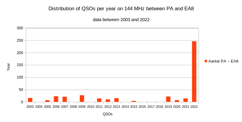
Fig 3:
When is there an opening?
The chart below shows that the months of July and August are the best. Assuming that the mechanism of an opening is a combination of E-skip and Tropo propagation that must coincide, this is correct. Statistically, most tropo openings between EA8 and CT/EA7 or south G are in the months of July and August. The 144 MHz Es season usually runs from May to July/beginning of August. The peak falls in June. The best chance that the tropo propagation and the Es skip coincide is the month of July.
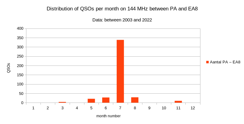
Fig 4:
The following chart shows the distribution per hour over the day. As I see it, that's the normal distribution of an E-skip opening. The two semi-durnials cycle can be recognized. The E-skip opening is for us the most important mechanism that allows us to reach the tropo duct. Therefore, it is dominant in the chart. So the most possible is in the morning in this case around between 11 and 13 UTC. This is a little later than you would expect from a normal E-skip opening. The second period falls between 16 and 18 UTC.
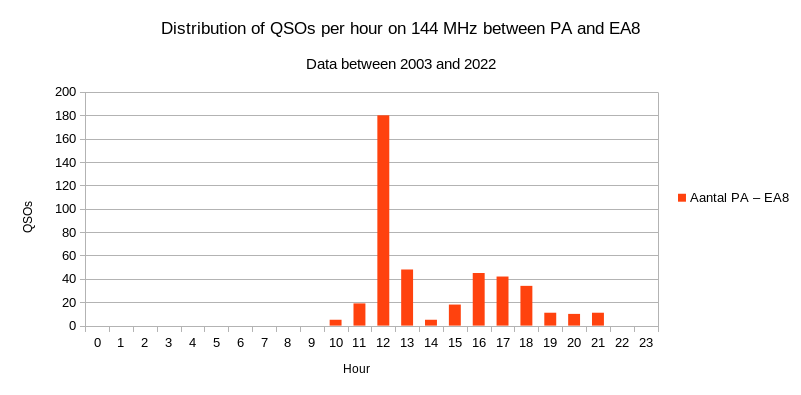
Fig 5:
The situation on July 22, 2022
Below is a map with Es-skip spots between 12:30 UTC and 13:00 UTC. The red lines is 144 MHz. The green lines spots 88 - 108 MHz FM stations. Dark blue is 50 MHz. The intensive number of spots between PA and EA8 is clearly visible. The reflection point for the first hop E-skip seems to be above the bay of biscay again.
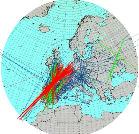
Fig 6: 2022-07-22 spots between 12:30 UTC en 13:00 UTC
When I zoom in on the midpoints you see that there is an extensive intensive reflection point above the Bay of Biscay. The second map only shows my spots and from my location the reflection point was probably more above the squares IN86/IN87. I deduce that my first hop signals entered the tropo duct somewhere west of Portgal. So there must have been a link between the two propagation mechanisms.
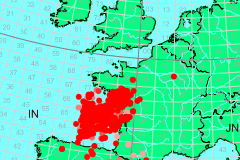
Fig 7: Collection of midpoints representing the E-skip reflection area 2022-07-22 between 12:35 UTC and 12:50 UTC.
I think somewhere above the squares IN51/IN50 or IN47 is the link with the de tropo Duct.
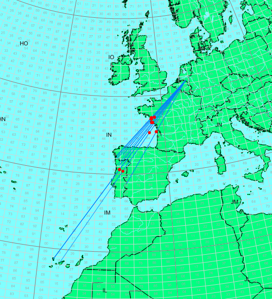
Fig 8: midpoints and spot lines from PE1ITR 2022-07-22 between 12:35 UTC and 12:50 UTC. Midpoint above IN86.
The two midpoints above portugal are artifacts and can be discarded.
The F5LEN tropo maps show a Tropo inversion layer extending from the northern Spanish/Portuguese coast down the African coast to beyond the Canary Islands.
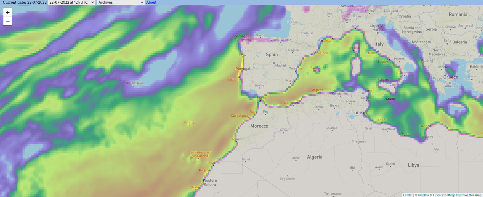
Fig 9:
The maps below show the situation a little better. It shows the modified refractive index at 6 different heights. This makes it easier to recognize the tropoduct between the Portuguese west coast to the south along the African coast. Very clearly in red the duct to IL18 at about 500m altitude. That is also a reason that no stations from IL28 were audible during the opening.
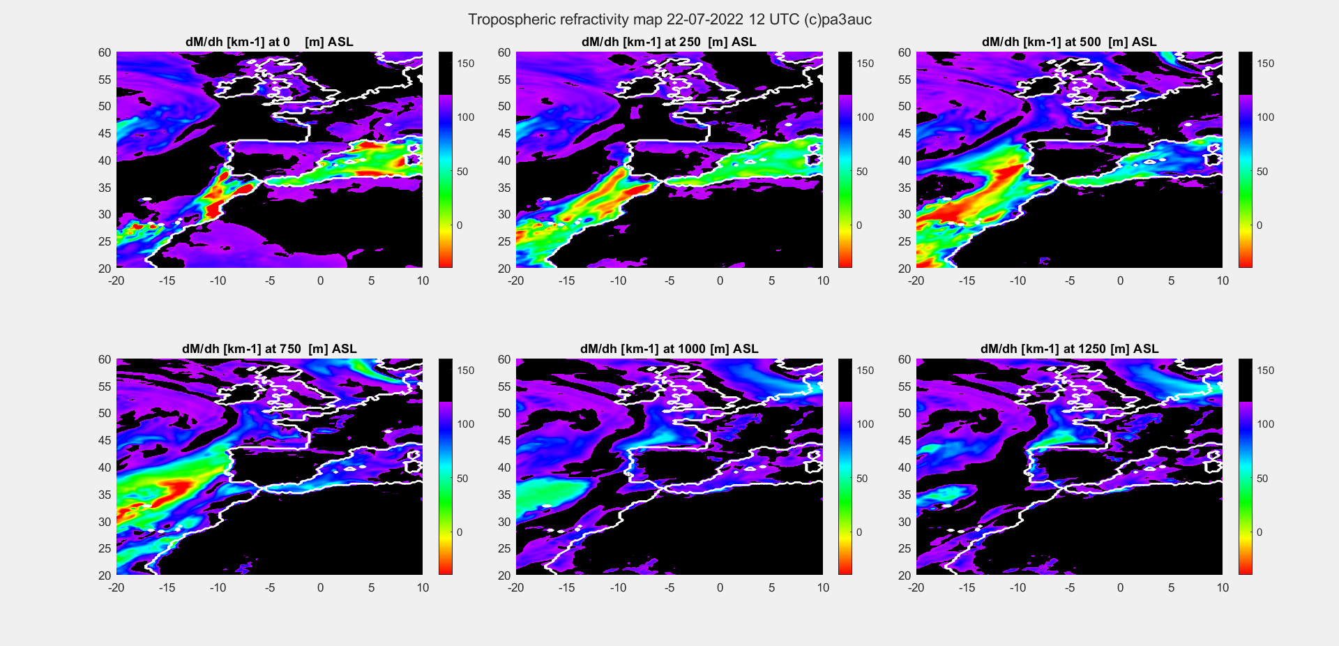
Fig 10: Better look with 6 height layers. There is clearly a tropoduct between Portugal and the Canary Islands at about 500m altitude.
The coupling of the E-skip VHF radio signals with the tropoduct layer.
The E-skip signal must enter the tropoduct with a very small angle (< 1 degree) to have a good coupling. And vise versa.
Assuming that after reflection against the E-layer my signals end up in or near the square IM47 (west coast Portugal). This is plausible given that the tropoduct starts there and at the time I was receiving CT stations from that area.
When this is the case, my signals will arrive with an angle between 1.5 and 2.2 degrees depending on the height of the E reflection layer. Not optimal but Es signals are quite strong and then the coupling between with the tropoduct does not have to be optimal.
In the picture with the cross section you can see that the entrance to the tropoduct is about 2000 km away. From balloon probe data, we know that there were also strong inversion layers closer to the coast.
It is also possible that the signals only enter the tropoduct after reflection against the sea surface. In that case, the entrance to tropo duct may be about 50 km further out to sea.
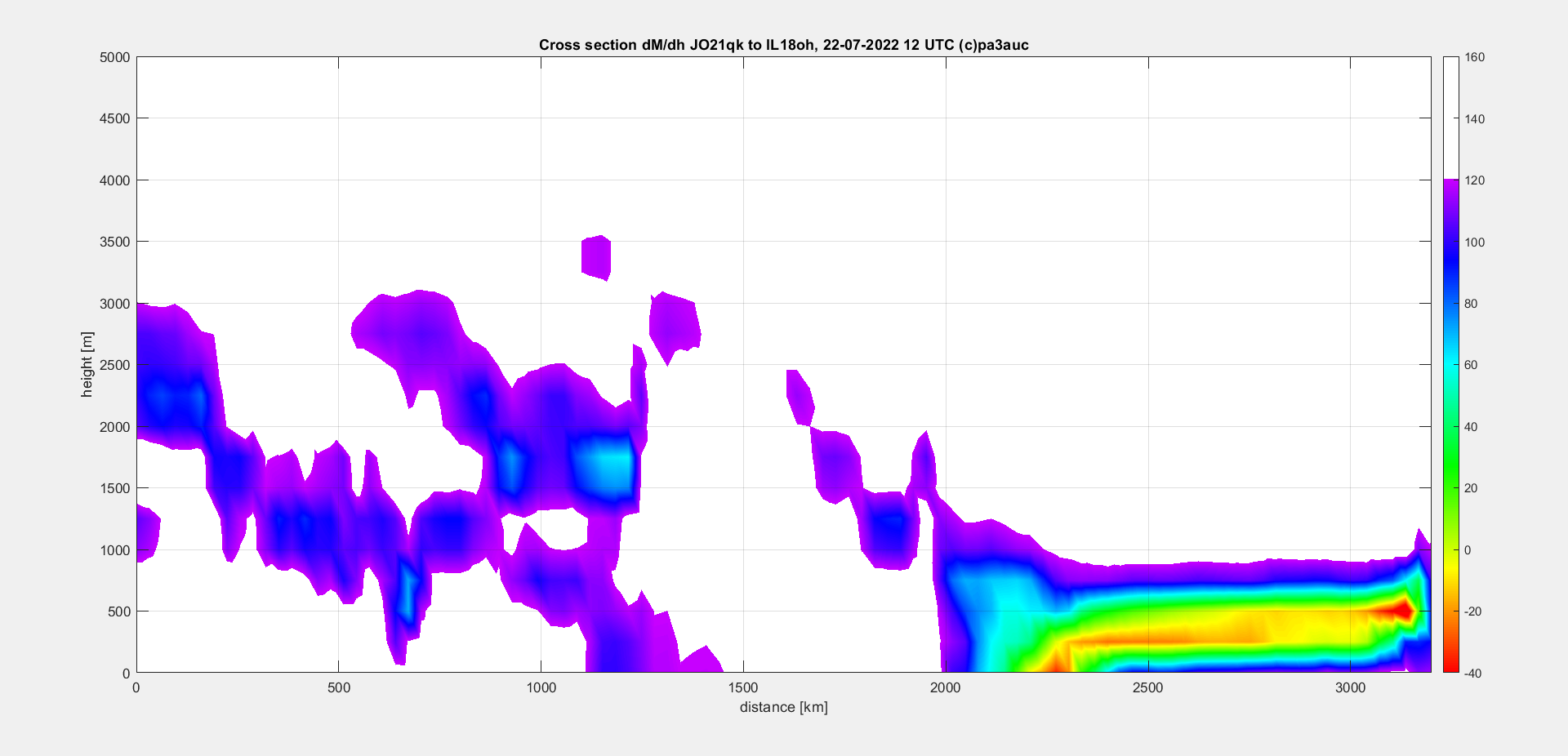
Fig 11: Cross section of the tropoduct in the path between PE1ITR and EA8DBM.
In summary, the image below shows the most likely scenario whereby QSOs on 144 MHz between PA and EA8 were possible on June 22, 2022.
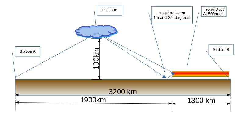
Fig 12:
Recognize a possible opening.
In summary, you can Recognize a possible opening in the following way:
- A radio progation opening at 144 MHz between PA and EA8 is uncommon, but when it does occur, it is most likely in the month of July.
- High Ionosferic MUF (> 144 MHz) over Bay of Biscay.
- You can work stations from CT/EA1/EA7.
- Enhanced Tropo Inversion Layers between EA8 and CT.
- The entry point of the tropoduct should be at approximately 1900 km distance in order for the Es signals to enter with a low angle of attack.
HOME | Go Back